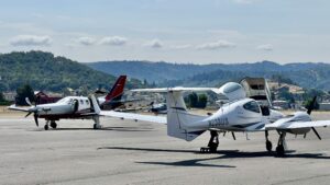
Located close to Stanford Hospital and Lucille Packard Children’s Hospital, Palo Alto Airport (KPAO) is an often used Angel Flight West mission destination.

Only a short distance from the San Francisco bay, this sea-level airport’s tower is in operation from 0700 to 2100 local. There are nine other airports within 20 NM, including Moffett Federal Airfield, just four nm SE, and San Carlos (SQL) seven miles NW. PAO is located under San Francisco International’s Class B airspace and there is Class C airspace around both Oakland International and San Jose International. San Jose’s Class C begins at 1500 feet, less than a mile to the SE. In addition, SFO’s approach path is just a short distance to the NE. Pilots, especially VFR pilots, should have a current San Francisco Terminal Chart and have spent some time reviewing the recommended arrival routing (more on this later).
PAO’s 70-foot wide runway is relatively short at 2443 feet. Runway 31 is the favored runway, but overruns on either landing or take-offs from runway 31 are dangerous because only 80 feet from the departure end is an 8-foot dike. In addition, there are wetlands near the approach end of 31 that can cause significant sink on short final, so keep your guard up. I used to be based at PAO and it wasn’t unusual to see the windsocks at opposite ends of the runway indicating opposing winds as the western winds swirl around the trees by the golf course to the west of the airport. The normal traffic pattern is at 800 feet on the Eastern side, but if you are cleared to enter on the Western side, the pattern altitude is 1000 feet.
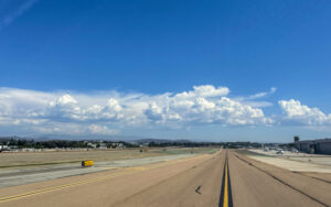
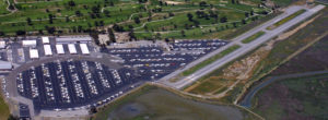
As you can see from the picture, PAO’s airport layout is unusual. You’ll typically want to pick up or drop off passengers at the Terminal building and transit parking area on the SE end of the field (bottom left of the picture). Navigating there can be interesting, so the easiest method might be to ask for progressive taxi instructions if you’re unfamiliar.
The terminal is minimalist, but there are restrooms and a public phone is available outside the terminal building to call a ride, cab, or the FSS. There is no flight planning computer available in the lobby but there are at the local FBOs. There isn’t a rental car agency on the airport, but there are rental car offices not too far away and there is contact information in the lobby. If you or your passengers need a rental car, it is best to be scheduled ahead of time.
Both Chevron (122.85) and Exxon (122.95) offer fueling from their respective trucks from 7 AM to dark. Chevron (Rossi Aircraft) has provided discounts for Angel Flight missions for many years and will provide fuel service after hours for a fee. Exxon (Palo Alto Fuel Service) also provides a discount on their truck. There is 100LL fuel available 24 hours at the self-service Exxon fuel pumps that are $.25-.30 cheaper than the truck fuel. Compare prices as the AFW truck discount may still be less expensive than the self-service.
There is a small sandwich shop/cafe called Abundant Air Cafe in a building at the south end of the field. There are also aviation supplies in a nearby building located beside the Palo Alto Flying Club. If you need maintenance or oxygen, they are available on the airport as well. Rossi Aircraft is located reasonably close to transit parking.
With the recommended arrival and departure procedures as well as Noise Abatement issues, and with the variety of Class B, C, and D airspace, not to mention airline arrival for SFO, OAK, and SJC, the smart pilot will spend some time reviewing the procedures and local charts before trying to operate into or out of PAO. Finally, with all of the potential GA traffic, we recommend using Flight Following as well.
If you need to pick up an IFR clearance when the tower is closed, check out http://www.dr-amy.com/rich/flying/kpao.html for detailed information.
The following URLs provide additional information:
For Noise Abatement procedures:
http://www.countyairports.org/docs/PilotInsert-PAO.pdf
For a very useful website containing a plethora of information on IFR or VFR operations, VFR, Noise Abatement procedures, a detailed map of the airport, and so forth, I strongly recommend:
http://www.dr-amy.com/rich/flying/kpao.html
This is the AirNav page for PAO:
http://www.airnav.com/airport/KPAO
This is the Stanford Flying Club’s website and it has a useful airport diagram:
http://www.flystanford.com/kpao.htm
More useful information about local operations:
